


Coordinates - GPS Formatter
Coordinates - GPS Formatter의 설명
다양한 형식으로 좌표를 결정하기 위한 간단하고 사용하기 쉬운 앱입니다.
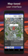
## 심플한 디자인 ##
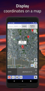
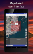
화면 중앙(회색 선이 교차하는 곳)에 위치를 찾으면 결과가 즉시 표시됩니다. 또는 수동으로 값을 입력할 수도 있습니다! 클립보드에서 위치를 가져올 수도 있습니다. 장소 이름, 도시, 주 또는 국가별로 위치를 검색하세요.
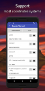
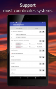
## 다양한 좌표 형식 지원 ##
이 앱은 단순한 경도나 위도 데이터만 표시하는 것이 아닙니다. 또한 UTM(Universal Transverse Mercator 좌표계), MGRS(Military Grid Reference System) 및 Georef(World Geographic Reference System)를 포함한 다양한 좌표 형식과 시스템을 지원합니다.
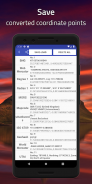
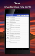
## 검색, 변환 및 변환 ##
여러 좌표 형식 간에 변환하고, 사진에서 좌표 값을 가져오거나, 변환할 지도에서 위치를 선택하세요.
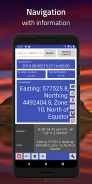
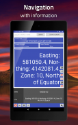
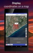
## 추적 및 탐색 ##
지도에 위치를 고정하고 내비게이션을 시작하세요. 나침반, 방위, 거리가 실시간으로 업데이트됩니다. 현장 사용을 위한 대규모 좌표 판독.
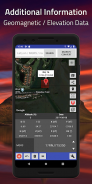
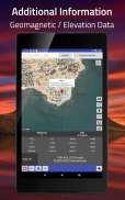
## 세계 자기 모델 계산기 ##
자기 편각, 강도, 자기 격자 변화 등과 같은 지자기장의 값을 계산합니다. 이 앱은 WMM(World Magnetic Model) 2015 및/또는 WMM 2015v2를 사용합니다.
지원되는 형식:
(WGS84) 십진수로 표시된 위도 및 경도
(WGS84) 도 및 십진수 분 단위의 위도 및 경도
(WGS84) 도, 분, 초 단위의 위도 및 경도
표준 UTM
나토 UTM
군용 그리드 참조 시스템(MGRS)
세계 지리 참조 시스템(Georef)
QTH 로케이터(그리드 스퀘어)/메이든헤드 그리드 스퀘어
(WGS84) 월드 메르카토르
(WGS84) 유사 세계 메르카토르/웹 메르카토르
지오해시
GARS(글로벌 영역 참조 시스템)
ISO 6709
자연지역번호
OS 내셔널 그리드 참조 [BNG]
OSGB36
what3words
아일랜드 그리드 참조/좌표
맵코드
플러스 코드(공개 위치 코드)
더치 그리드
인도 칼리안푸르 1975
우편번호 열기
지오해시-36
과테말라 GTM
QND95 / 카타르 내셔널 그리드
EPSG:4240 / 인도 1975
EPSG:2157 / IRENET95 / 아일랜드 가로 메르카토르
SR-ORG:7392 / KOSOVAREF01
EPSG:23700 / HD72 / EOV
케르타우(RSO) / RSO 말라야(m)
팀발라이 1948 / RSO 보르네오 (m)
에스토니아어 1997
EPSG:3059 / LKS92 / 라트비아 TM
NZGD49 / NZMG
EPSG:2193 / NZGD2000 / NZTM
EPSG:21781 / 스위스 CH1903 / LV03
EPSG:2056 / 스위스 CH1903+ / LV95
EPSG:2100 / GGRS87 / 그리스 그리드
EPSG:3035 / ETRS89 확장 / LAEA 유럽
NTF(파리) / 램버트 존 II
아크 1950
알바니아어 1987 / 가우스-크루거 구역 4
아메리칸 사모아 1962 / 아메리칸 사모아 램버트
CR05 / CRTM05
HTRS96 / 크로아티아
S-JTSK / 크로바크
홍콩 1980 그리드 시스템
ISN2004 / 램버트 2004
ED50 / 이라크 내셔널 그리드
카르발라 1979 / 이라크 내셔널 그리드
이스라엘 1993 / 이스라엘 TM 그리드
JAD2001 / 자메이카 미터법 격자
ED50 / 조던 TM
KOC 램버트
Deir ez Zor / 레반트 스테레오그래픽
데이르 에즈 조르 / 시리아 램버트
LGD2006 / 리비아 TM
LKS94 / 리투아니아 TM
룩셈부르크 1930 / 가우스
아크 1950 / UTM 구역 36S
Tananarive(파리)/Laborde 그리드 근사
MOLDREF99 / 몰도바 TM
몬세라트 1958 / 영국 서인도 제도 그리드
Amersfoort / RD New -- 네덜란드 - 네덜란드 - 네덜란드어
RGNC91-93 / 램버트 뉴칼레도니아
NZGD2000 / NZCS2000
팔레스타인 1923 / 팔레스타인 벨트
파나마-콜론 1911
핏케언 2006 / 핏케언 TM 2006
ETRS89 / 폴란드 CS92
ETRS89 / 포르투갈 TM06
NAD83(NSRS2007) / 푸에르토리코 및 버진아일랜드
카타르 1974 / 카타르 내셔널 그리드
풀코보 1942(58) / 스테레오70
영국 서인도 제도 그리드
RGSPM06 / UTM 구역 21N
아인 엘 아브드 / 아람코 램버트
Yoff / UTM 구역 28N
SVY21 / 싱가포르 TM
슬로베니아 1996 / 슬로베니아 내셔널 그리드
대한민국 2000 / 통합CS
마드리드 1870(마드리드) / 스페인
칸다왈라 / 스리랑카 그리드
SLD99 / 스리랑카 그리드 1999
Zanderij / UTM 구역 21N
Hu Tzu Shan 1950 / UTM 구역 51N
로메 / UTM 구역 31N
TGD2005 / 통가 지도 그리드
미국 국립 지도집 동일 지역
WGS 84 / 남극 극지 입체사진
WGS 84 / NSIDC 해빙 극지 입체 북쪽
풀코보 1942 / SK42 / CK-42
PZ-90 / ПЗ-90
NAD27
H3
GDM2000
그리고 더
앞으로 더 많은 형식과 기능이 정기적으로 추가될 예정입니다.
Coordinates - GPS Formatter - APK 정보
APK 버전: 4.11.5패키지: com.myice92.coordinatesCoordinates - GPS Formatter의 최신 버전
다른 버전들


동일 카테고리의 앱


